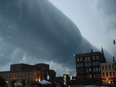
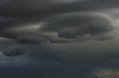
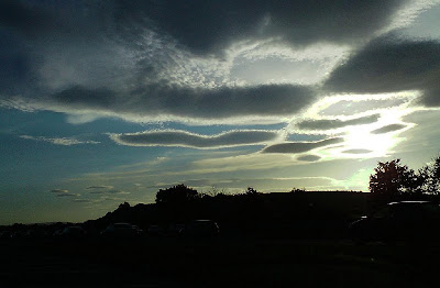
"Crop Circles in the Sky", with cute little tails sticking out of them

Punch Hole Clouds may appear as a circular or oval holes in a layer of supercooled clouds; sometimes they assume a form of a perfect circle and persist for quite a long time, drifting together with the cloud layer. One explanation seems to blame the air traffic (the jet contrail intersections) combined with a thermal inversion (a circular motion of a rising warm air). Here is one, observed over the Gunnison Valley in Colorado:

Another strange hole in the cloud, reported from Mobile, Alabama USA, Dec. 2003 (and covered by BBC News):

Photo taken in Melbourne, Australia in 2003:

It seems both rising and sinking air currents can create the same effect. Sometimes a very stable, uniform layer of high-altitude clouds can get "punched though" by a pocket of cold air, which sinks toward the ground - creating the circular hole formation.

These "cloud holes" can look like the footprints of some celestial being (UFO enthusiasts rejoice!) or can be amazingly round, like this pair observed in Gallatin, Tennessee by Wayne Carter:

NASA takes satellite images of this phenomenon
NASA Terra satellite equipped with the Moderate Resolution Imaging Spectroradiometer (MODIS) has captured these images over Acadiana area in southern Louisiana - a splattering of round holes actually stretched over several states: Oklahoma, Arkansas, Louisiana, and Texas. Some were elongated, some appeared to have smaller clouds inside them.
"This strange phenomenon resulted from a combination of cold temperatures, air traffic, and perhaps unusual atmospheric stability. The cloud blanket on January 29 consisted of supercooled clouds. Supercooled clouds contain water droplets that remain liquid even though the temperature is well below freezing, and such clouds are not unusual. As aircraft from the Dallas-Fort Worth airport passed through these clouds, tiny particles in the exhaust came into contact with the supercooled water droplets, which froze instantly. The larger ice crystals fell out of the cloud deck, leaving behind the “holes,” while the tiniest ice particles in the center remained aloft."


Cloud Vortices: another "holey" sky phenomena
Theodore von Karman's "Cloud Vortices" are something else, again: they form when the wind encounters a barrier - such as the Aleutian islands, in this case - and the flowing eddies of cloud create a weird pattern. The image you see below was photographed from the International Space Station, and the animation shows the double row of vortices, which rotate opposite from each other.

More Incredible and Fascinating Clouds
...that make our sky worthy to look at from time to time (those who only look at the computer monitor, take note). Here is an extremely strong thunderstorm cloud that brewed over northwest Calgary:
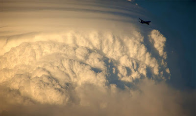

Another supercell cloud in Alberta skies, this time over Edmonton:

'shrooms:

Another cloud "wave", similar to the one over South Dakota Badlands

Roll clouds... get into a small plane and start "surfing" them! -


A Cloud Angel

Two light-sabers get crossed in the sky:

A fire-breathing rabbit-dragon, and a fantastic cloud edge:

A "genie", coming out of a bottle:

Spectacular lenticulars in the morning light... and a whole "pancake" stack of them, over at Mount Rainier in Washington:


Stormy:

An interesting rainbow effect:

Nacreous clouds :
Nacreous clouds, sometimes called mother-of-pearl clouds, are rare but once seen are never forgotten. They are mostly visible within two hours after sunset or before dawn when they blaze unbelievably bright with vivid and slowly shifting iridescent colours. They are filmy sheets slowly curling and uncurling, stretching and contracting in the semi-dark sky. Compared with dark scudding low altitude clouds that might be present, nacreous clouds stand majestically in almost the same place - an indicator of their great height.
They need the very frigid regions of the lower stratosphere some 15 - 25 km (9 -16 mile) high and well above tropospheric clouds. They are so bright after sunset and before dawn because at those heights they are still sunlit.
They are seen mostly during winter at high latitudes like Scandinavia, Iceland, Alaska and Northern Canada. Sometimes, however, they occur as far south as England. They can be less rare downwind of mountain ranges. Elsewhere their appearance is often associated with severe tropospheric winds and storms.
Nacreous clouds far outshine and have much more vivid colours than ordinary iridescent clouds which are very much poor relations and seen frequently all over the world.

Prepare to get squashed, Earthlings! -

Some other Wierd Cloud Formations


Punch Hole Clouds may appear as a circular or oval holes in a layer of supercooled clouds; sometimes they assume a form of a perfect circle and persist for quite a long time, drifting together with the cloud layer. One explanation seems to blame the air traffic (the jet contrail intersections) combined with a thermal inversion (a circular motion of a rising warm air). Here is one, observed over the Gunnison Valley in Colorado:

Another strange hole in the cloud, reported from Mobile, Alabama USA, Dec. 2003 (and covered by BBC News):

Photo taken in Melbourne, Australia in 2003:

It seems both rising and sinking air currents can create the same effect. Sometimes a very stable, uniform layer of high-altitude clouds can get "punched though" by a pocket of cold air, which sinks toward the ground - creating the circular hole formation.

These "cloud holes" can look like the footprints of some celestial being (UFO enthusiasts rejoice!) or can be amazingly round, like this pair observed in Gallatin, Tennessee by Wayne Carter:

NASA takes satellite images of this phenomenon
NASA Terra satellite equipped with the Moderate Resolution Imaging Spectroradiometer (MODIS) has captured these images over Acadiana area in southern Louisiana - a splattering of round holes actually stretched over several states: Oklahoma, Arkansas, Louisiana, and Texas. Some were elongated, some appeared to have smaller clouds inside them.
"This strange phenomenon resulted from a combination of cold temperatures, air traffic, and perhaps unusual atmospheric stability. The cloud blanket on January 29 consisted of supercooled clouds. Supercooled clouds contain water droplets that remain liquid even though the temperature is well below freezing, and such clouds are not unusual. As aircraft from the Dallas-Fort Worth airport passed through these clouds, tiny particles in the exhaust came into contact with the supercooled water droplets, which froze instantly. The larger ice crystals fell out of the cloud deck, leaving behind the “holes,” while the tiniest ice particles in the center remained aloft."


Cloud Vortices: another "holey" sky phenomena
Theodore von Karman's "Cloud Vortices" are something else, again: they form when the wind encounters a barrier - such as the Aleutian islands, in this case - and the flowing eddies of cloud create a weird pattern. The image you see below was photographed from the International Space Station, and the animation shows the double row of vortices, which rotate opposite from each other.

More Incredible and Fascinating Clouds
...that make our sky worthy to look at from time to time (those who only look at the computer monitor, take note). Here is an extremely strong thunderstorm cloud that brewed over northwest Calgary:


Another supercell cloud in Alberta skies, this time over Edmonton:

'shrooms:

Another cloud "wave", similar to the one over South Dakota Badlands

Roll clouds... get into a small plane and start "surfing" them! -


A Cloud Angel

Two light-sabers get crossed in the sky:

A fire-breathing rabbit-dragon, and a fantastic cloud edge:

A "genie", coming out of a bottle:

Spectacular lenticulars in the morning light... and a whole "pancake" stack of them, over at Mount Rainier in Washington:


Stormy:

An interesting rainbow effect:

Nacreous clouds :
Nacreous clouds, sometimes called mother-of-pearl clouds, are rare but once seen are never forgotten. They are mostly visible within two hours after sunset or before dawn when they blaze unbelievably bright with vivid and slowly shifting iridescent colours. They are filmy sheets slowly curling and uncurling, stretching and contracting in the semi-dark sky. Compared with dark scudding low altitude clouds that might be present, nacreous clouds stand majestically in almost the same place - an indicator of their great height.
They need the very frigid regions of the lower stratosphere some 15 - 25 km (9 -16 mile) high and well above tropospheric clouds. They are so bright after sunset and before dawn because at those heights they are still sunlit.
They are seen mostly during winter at high latitudes like Scandinavia, Iceland, Alaska and Northern Canada. Sometimes, however, they occur as far south as England. They can be less rare downwind of mountain ranges. Elsewhere their appearance is often associated with severe tropospheric winds and storms.
Nacreous clouds far outshine and have much more vivid colours than ordinary iridescent clouds which are very much poor relations and seen frequently all over the world.

Prepare to get squashed, Earthlings! -

Some other Wierd Cloud Formations


